Toronto, Ontario--(Newsfile Corp. - November 3, 2025) - Omai Gold Mines Corp. (TSXV: OMG) (OTCQB: OMGGF) ("Omai Gold" or the "Company") is pleased to announce assay results from the next phase of drilling at its 100% owned Omai Gold Project in Guyana, South America. The current positive drilling results are from two near-surface exploration targets that were identified from trenching, geophysics and historical data. Assays are reported for 11 drill holes totalling 2,615m with 6 holes on the BBH target and 5 holes from the Camp Zone (Table 1). A total of 64 drill holes have been completed to date this year on the Omai property, totalling 30,297m.
The deep hole 25ODD-122, testing the blue-sky potential at depth below the Wenot deposit, ended at a downhole depth 2,014m. It was successful in intersecting approximately 280m of the Wenot shear corridor at a depth of approximately 1,120m from surface or 600 m below the known Wenot gold deposit. Assays are pending.
Five rigs are currently drilling on the Wenot deposit with the goal of completing an additional 8,000m before year end.
Highlights from the recent exploration holes include:
BBH Target
- Hole 25ODD-131
- 20.33 g/t Au over 5.30m
- Including 35.61 g/t Au over 3m
- 20.33 g/t Au over 5.30m
Camp Zone Target
- Hole 25ODD-135
- 2.72 g/t Au over 16.30m
- Including 9.05 g/t Au over 4m
- 2.72 g/t Au over 16.30m
- Hole 25ODD-136
- 2.05 g/t Au over 7.50m
- Including 11.32 g/t Au over 1m
- 2.05 g/t Au over 7.50m
- Hole 25ODD-138
- 0.85 g/t Au over 12.70m
- Including 1.32 g/t Au over 6m
- 0.85 g/t Au over 12.70m
Elaine Ellingham, President & CEO commented, "We are pleased to provide these exciting results from two of our exploration targets, both nearby the Wenot and Gilt Creek gold deposits. Although we have kept our focus on expanding the Wenot open pit deposit and driving forward to an updated Preliminary Economic Study with a much expanded Omai mine plan, we still believe that identifying and working to define additional satellite deposits will create further value to the project. A few of our exploration targets have evidence of higher grade mineralization and present possibilities for satellite pits that could positively impact early cash flow and overall NPV. With today's results, we will further model these targets to guide additional drilling in these clearly prospective areas."
"We are also pleased to announce that the deep hole 25ODD-122, drilled to test the blue sky potential of the Wenot deposit at depth successfully reached 2,014m (Photo 1). The hole flattened significantly, not unexpectedly but this allowed us to cross over 280m of the Wenot shear corridor at a vertical depth of about 1,120m, which is at least 600m below the deepest known extent of the Wenot deposit. Since we have identified the Wenot deposit along a 2.5 km strike length, this potential depth extension bodes well for the long-term potential of the project. Proving the shear extends this far to depth is a great win. We await assay results. Although the Omai Mineral Resource Estimate is quite sizeable, the geological extension to depth of the shear corridor that hosts the gold mineralization in the upper part of Wenot provides the possibility for an even longer mine life. Large-scale mine developments support long-term employment and sustainable communities. Omai is located 10km from the only road from Georgetown, the capital city of Guyana, to Brazil. Paving is well underway on this road and there are longer-term plans to establish this as an access to a major deep-water port planned on the coast of Guyana, east of Georgetown. This infrastructure would further benefit the Omai project."
BBH Target Drill Results (Map 1)
A series of trenches and historical and recent drill holes identified significant near-surface high-grade gold mineralization. A series of flat-lying, saprolite-hosted ladder veins have also been observed in fresh rock within a nearby old adit (likely Anaconda, circa 1948). These ladder veins appear to occur between two northeast-trending structures. Drilling in 2021 intersected 1.7 g/t Au over 7.5m, and 3.15 g/t Au over 3.0m and six of eleven 2022 trench samples assayed over 6 g/t Au, including three that assayed over 10 g/t Au (News Release Dated February 24, 2022). Seven drill holes were recently completed along the interpreted 600m trend of this zone. Results for five of the seven holes have been received and results for the additional two holes are pending.
Most successful, hole 25ODD-131 tested the continuity of the shallow gold mineralization within a series of flat-lying quartz veins and veinlets identified in trenches located 100m to the west and also 300m to the northeast. Hole 131, drilled vertically, intersected a near-surface, high-grade zone of 20.33 g/t Au over 5.30m that included 35.61 g/t Au over 3.0m, at a depth of -50m. Another zone, although lower grade, returned 0.31 g/t Au over 6m at a depth of -86m.
Hole 25ODD-133, an inclined hole collared 100m to the northeast of hole 131, intersected several intervals of anomalous gold with best results of 1.24 g/t Au over 1.5m and 0.76 g/t Au over 1.5m.
Hole 25ODD-129, located 400m northeast of hole 131, tested the broader trend of the targeted zone with an inclined hole. It intersected a sequence of chlorite-altered basalt cut by a couple of diorite dikes. Assays include 0.41 g/t Au over 10.50m, within the basalt. These inclined holes are proving less effective for exploration of the known flat-lying gold zones in this area.
Hole 25ODD-137, another inclined hole, is located 550m ENE of hole 131. It intersected shallow mineralization, including 0.53 g/t Au over 4.5m, 0.38 g/t Au over 4.5m, and 0.78 g/t Au over 3.0m. All of these intersections are at a vertical depth of less than -52m. Nearby, an historic drill hole intersected 0.74 g/t Au over 94m near surface. Given the proximity to surface and being hosted within unconsolidated material, it is possible that with further drilling these could contribute to a future Mineral Resource Estimate.
Hole 25ODD-134 was a vertical hole testing over 600m east of hole 131, along the projected strike. It intersected only 0.75 g/t Au over 1.5m which is surprising since a nearby historical drill hole intersected multiple gold-bearing zones, including 0.72g/t Au over 15m, 0.82 g/t Au over 9m, 1.24 g/t over 3m, and 0.72 g/t Au over 9m. The orientation of these ladder veins between two structures can prove challenging to model but with these additional holes, the orientations are becoming better understood.
This exploration further demonstrates significant near-surface gold mineralization in this area and additional drilling is warranted. These holes proved useful in better understanding the orientation and distribution of gold zones. A small near-surface high-grade resource in this area could be beneficial as a smaller, higher grade, satellite pit to a future mine plan for the larger Omai project. Results from an additional two holes in this area are pending.
Camp Zone Target
The Camp Zone Target is located approximately 300-500m west of the Wenot deposit. The Wenot shear corridor extends through this area, with the expected Central Quartz Feldspar Porphyry ('CQFP') occurring at the volcano-sedimentary contact, as usual. In this area, the shear corridor and CQFP appear slightly offset or splayed off the otherwise straight-line projection of the main Wenot shear.
Most significant new results from the Camp Zone include 2.72 g/t Au over 16.3m in hole 25ODD-135 at a depth of -115m, 6.81 g/t Au over 1m and 2.05 g/t Au over 7.5m in hole 25ODD-136 at a depth of -180m, and 0.85 g/t Au over 12.70m in hole 25ODD-138, also above -200m depth. In all of these cases, the mineralization occurred within the felsic dikes, believed to be correlated to the preferentially mineralized "Dike Corridor" seen at the main Wenot deposit, and to previously drilled gold-bearing felsic dikes along strike in the Camp Zone.
Hole 25ODD-130, located in the center of Camp Zone, returned several intercepts of anomalous gold, 0.78g/t Au over 5.1m and 1.38 g/t Au over 4m, at a vertical depth of less than -82m.
Hole 25ODD-132, collared approximately 100m north, behind hole 25ODD-130, returned narrow intercepts of anomalous gold, including 1.98 g/t Au over 2.1m, 0.69 g/t Au over 2.2m, and 0.77 g/t Au over 1.5m. These intersections are further north than the intercepts in hole 130 and are at depths of less than -50m.
Drilling in the Camp Zone area has now identified mineralization occurring along a 450m strike. The best historical intersections include 1.56 g/t Au over 10.5m, 1.57 g/t Au over 7.5m, 3.0 g/t Au over 10.5m, and 5.75 g/t Au over 9.9m. More recently, the Company intersected 2.53 g/t Au over 9.9m in hole 22ODD-047, and early this year hole 25ODD-098 intersected 0.59 g/t Au over 10.5m and 0.42 g/t Au over 18.4m within the same horizon (News Release Dated March 27, 2025). Most of these intersections are at a depth of less than -150m, so attractive as a potential satellite pit. However, it is possible that with further drilling the Camp Zone may prove to be a continuation of the Wenot West gold mineralization, with a minor offset or deflection. Seven close-spaced holes were drilled in this area in September and assays are pending for two holes. Additional drilling will be planned once all results are received and reviewed.
Deep Hole 25ODD-122
Hole 122 ended at a downhole depth of 2,014m. It was successful in identifying the depth extension of the Wenot shear corridor at a depth of 1120m or approximately 600m below the deepest known parts of the Wenot gold deposit. This hole also supports the model that the Wenot shear and the central contact dip almost vertically, with an estimated 85° dip to the north, based on the visually distinctive CQFP that persistently occurs at the contact between the volcanic rocks on the north and the sedimentary rocks on the south. Hole 122 did not continue beyond 2,014m due to physical drilling limitations, and although it tested a wide portion of the Wenot shear, it did not reach the southern limit. Assays are pending.
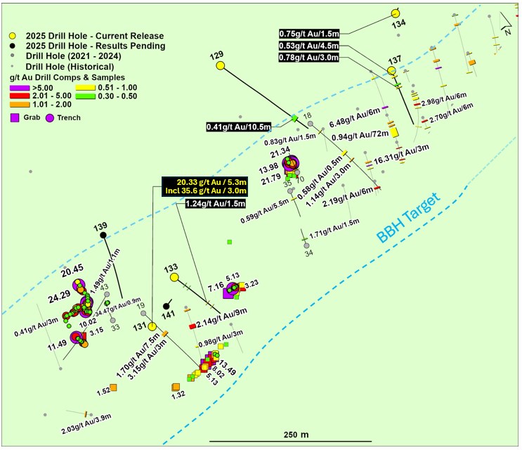
Figure 1. Map Showing BBH Drill Hole Results and Compilation of Trenching and Sampling Results
To view an enhanced version of this graphic, please visit:
https://images.newsfilecorp.com/files/8712/272925_f9c00b1744c5fa66_001full.jpg
Table 1. Recent Wenot Drill Results*
| DDH | From | To | Interval | Grade g/t Au) |
| 25ODD-129 (BBH) | 211.0 | 221.5 | 10.5 | 0.41 |
| 25ODD-130 (CZ) | 85.5 | 90.6 | 5.1 | 0.78 |
| 103.0 | 107.0 | 4.0 | 1.38 | |
| 172.5 | 174.0 | 1.5 | 0.42 | |
| 25ODD-131 (BBH) | 45.7 | 51.0 | 5.3 | 20.33 |
| Including | 46.5 | 49.5 | 3.0 | 35.61 |
| 80.0 | 86.0 | 6.0 | 0.31 | |
| 167.5 | 169.0 | 1.5 | 0.31 | |
| 25ODD-132 (CZ) | 4.5 | 6.6 | 2.1 | 1.98 |
| 33.0 | 35.2 | 2.2 | 0.69 | |
| 54.0 | 55.5 | 1.5 | 0.77 | |
| 25ODD-133 (BBH) | 48.0 | 49.5 | 1.5 | 0.32 |
| 66.2 | 67.7 | 1.5 | 0.40 | |
| 157.5 | 159.0 | 1.5 | 1.24 | |
| 178.5 | 180.0 | 1.5 | 0.76 | |
| 25ODD-134 (BBH) | 113.5 | 115.0 | 1.5 | 0.75 |
| 25ODD-135 (CZ) | 75.0 | 75.6 | 0.6 | 0.52 |
| 79.5 | 81.0 | 1.5 | 0.51 | |
| 138.9 | 155.2 | 16.3 | 2.72 | |
| Including | 141.5 | 145.5 | 4.0 | 9.05 |
| 25ODD-136 (CZ) | 225.0 | 226.0 | 1.0 | 6.81 |
| 241.5 | 249.0 | 7.5 | 2.05 | |
| Including | 244.0 | 245.0 | 1.0 | 11.32 |
| 25ODD-137 (BBH) | 16.5 | 21.0 | 4.5 | 0.53 |
| 41.5 | 46.0 | 4.5 | 0.38 | |
| 52.0 | 55.0 | 3.0 | 0.78 | |
| 25ODD-138 (CZ) | 178.0 | 179.5 | 1.5 | 0.43 |
| 262.0 | 274.7 | 12.7 | 0.85 | |
| Including | 263.0 | 269.0 | 6.0 | 1.32 |
| 347.5 | 349.0 | 1.5 | 0.46 |
*True widths vary as mineralization at Wenot is generally hosted within stockwork vein systems with alteration halos, with an estimated true width range of 70-90%. Cut-off grade of 0.30 g/t Au with maximum 3.0m internal dilution is applied. Grades are uncapped unless otherwise noted.
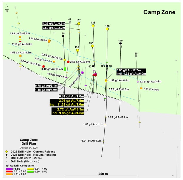
Figure 2. Map Showing Camp Zone Drill Hole Results
To view an enhanced version of this graphic, please visit:
https://images.newsfilecorp.com/files/8712/272925_f9c00b1744c5fa66_002full.jpg
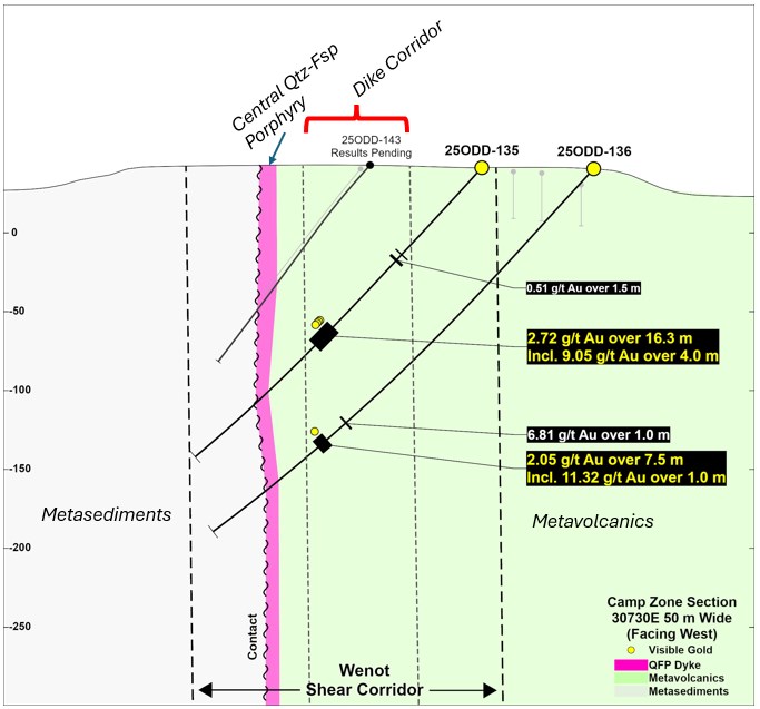
Figure 3. Cross-Section DDH 25ODD-135 and DDH 25ODD-136 (Camp Zone)
To view an enhanced version of this graphic, please visit:
https://images.newsfilecorp.com/files/8712/272925_f9c00b1744c5fa66_003full.jpg
Table 2. Drill Hole Coordinates
| Hole ID | Azimuth | Inclination | Easting | Northing | Length | Status |
| (degrees) | (degrees) | (m) | ||||
| 25ODD-122 | 142 | -60 | 304648 | 602870 | 2013.6 | Pending |
| 25ODD-129 | 147 | -52 | 304160 | 602829 | 256.5 | Reporting |
| 25ODD-130 | 178 | -51 | 303677 | 602020 | 250.6 | Reporting |
| 25ODD-131 | 0 | -90 | 303923 | 602486 | 208.7 | Reporting |
| 25ODD-132 | 178 | -55 | 303681 | 602114 | 403.6 | Reporting |
| 25ODD-133 | 148 | -65 | 303981 | 602546 | 220.5 | Reporting |
| 25ODD-134 | 20 | -88 | 304442 | 602812 | 152.4 | Reporting |
| 25ODD-135 | 177 | -48 | 303728 | 602034 | 259.2 | Reporting |
| 25ODD-136 | 178 | -48 | 303731 | 602106 | 334.7 | Reporting |
| 25ODD-137 | 178 | -60 | 304406 | 602731 | 170.1 | Reporting |
| 25ODD-138 | 180 | -48 | 303780 | 602095 | 358.7 | Reporting |
Quality Control
Omai maintains an internal QA/QC program to ensure sampling and analysis of all exploration work is conducted in accordance with best practices. Certified reference materials, blanks and duplicates are entered at regular intervals. Samples are sealed in plastic bags.
Drill core samples (halved-core) were shipped to Act Labs and some batches to MSALABS, both certified laboratories in Georgetown Guyana, respecting the best chain of custody practices. At the laboratory, samples are dried, crushed up to 80% passing 2 mm, riffle split (250 g), and pulverized to 95% passing 105 μm, including cleaner sand. Fifty grams of pulverized material is then fire assayed by atomic absorption spectrophotometry (AA). Initial assays with results above 3.0 ppm gold are re-assayed using a gravimetric finish. For samples with visible gold, two separate 250g or 500g pulverized samples are prepared, with 50 grams of each fire assayed by atomic absorption spectrophotometry, with assays above 3.0 ppm gold being re-assayed using a gravimetric finish. Certified reference materials and blanks meet with QA/QC specifications.
Qualified Person
Elaine Ellingham, P.Geo., is a Qualified Person (QP) under National Instrument 43-101 "Standards of Disclosure for Mineral Projects" and has reviewed the technical information contained in this news release. Ms. Ellingham is a director and officer of the Company and is not considered to be independent for the purposes of National Instrument 43-101.
ABOUT OMAI GOLD
Omai Gold Mines Corp. is a Canadian gold exploration and development company focused on rapidly expanding the two orogenic gold deposits at its 100%-owned Omai Gold Project in mining-friendly Guyana, South America. The Company has established the Omai Gold Project as one of the fastest growing and well-endowed gold camps in the prolific Guiana Shield. In August 2025, the Company announced a 96% increase to the Wenot Gold Deposit NI 43-101 Mineral Resource Estimate1 (MRE) to 970,000 ounces of gold (Indicated) averaging 1.46 g/t Au, contained in 20.7 Mt and 3,717,000 ounces of gold (Inferred MRE) averaging 1.82 g/t Au, contained in 63.4 Mt. This brings the global MRE at Omai, including the Wenot and adjacent Gilt Creek deposits, to 2,121,000 ounces of gold (Indicated MRE) averaging 2.07 g/t Au in 31.9 Mt and 4,382,000 ounces of gold (Inferred MRE) averaging 1.95 g/t Au in 69.9 Mt. A baseline PEA announced in April 2024, contemplated an open pit-only development scenario and included less than 30% of the new Mineral Resource Estimate for Omai. Five drills are currently active on the property: at Wenot the focus is to optimize the upcoming PEA, to further test the limits of the deposit, including both east and west, and to commence upgrading the large Inferred MRE to Indicated. Additional drilling will continue to explore certain known gold occurrences for possible near-surface higher-grade satellite deposits. An updated PEA is planned for H1 2026 to include the expanded Wenot open pit deposit and the adjacent Gilt Creek underground deposit. The Omai Gold Mine produced over 3.7 million ounces of gold from 1993 to 20052, ceasing operations when gold was below US$400 per ounce. The Omai site significantly benefits from existing infrastructure and is connected to the two largest cities in Guyana, Georgetown and Linden.
1 NI 43-101 Technical Report dated October 9, 2025 titled "UPDATED MINERAL RESOURCE ESTIMATE AND TECHNICAL REPORT ON THE OMAI GOLD PROPERTY, POTARO MINING DISTRICT NO.2, GUYANA" was prepared by P&E Mining Consultants Inc. and is available on www.sedarplus.ca and on the Company's website.
2 Past production at the Omai Mine (1993-2005) is summarized in several Cambior Inc. documents available on www.sedarplus.ca, including March 31, 2006 AIF and news release August 3, 2006.
For further information, please see our website www.omaigoldmines.com or contact:
Elaine Ellingham, P.Geo.
President & CEO
elaine@omaigoldmines.com
+1.416.473.5351
Neither the TSX Venture Exchange nor its Regulation Services Provider (as that term is defined in the policies of the TSX Venture Exchange) accepts responsibility for the adequacy or accuracy of this release.
Cautionary Note Regarding Forward-Looking Statements
This news release includes certain "forward-looking statements" under applicable Canadian securities legislation. Forward-looking statements include, but are not limited to, statements with respect to the timing of completion of the drill program, and the potential for the Omai Gold Project to allow Omai to build significant gold Mineral Resources at attractive grades, and forward-looking statements are necessarily based upon a number of estimates and assumptions that, while considered reasonable, are subject to known and unknown risks, uncertainties and other factors which may cause the actual results and future events to differ materially from those expressed or implied by such forward-looking statements. Such factors include, but are not limited to general business, economic, competitive, political and social uncertainties; delay or failure to receive regulatory approvals; the price of gold and copper; and the results of current exploration. Further, the Mineral Resource data set out in this news release are estimates, and no assurance can be given that the anticipated tonnages and grades will be achieved or that the indicated level of process recovery will be realized. There can be no assurance that forward-looking statements will prove to be accurate, as actual results and future events could differ materially from those anticipated in such statements. Accordingly, readers should not place undue reliance on forward-looking statements. The Company disclaims any intention or obligation to update or revise any forward-looking statements, whether as a result of new information, future events or otherwise, except as required by law.
Cautionary Note Regarding Mineral Resource Estimates
Until mineral deposits are actually mined and processed, Mineral Resources must be considered as estimates only. Mineral Resource Estimates that are not Mineral Reserves have not demonstrated economic viability. The estimation of Mineral Resources is inherently uncertain, involves subjective judgement about many relevant factors and may be materially affected by, among other things, environmental, permitting, legal, title, taxation, socio-political, marketing, or other relevant risks, uncertainties, contingencies and other factors described in the Company's public disclosure available on SEDAR+ at www.sedarplus.ca. The Inferred Mineral Resource in this estimate has a lower level of confidence than that applied to an Indicated Mineral Resource and must not be converted to a Mineral Reserve. It is reasonably expected that the majority of the Inferred Mineral Resource could be upgraded to an Indicated Mineral Resource with continued exploration. The accuracy of any Mineral Resource Estimates is a function of the quantity and quality of available data, and of the assumptions made and judgments used in engineering and geological interpretation, which may prove to be unreliable and depend, to a certain extent, upon the analysis of drilling results and statistical inferences that may ultimately prove to be inaccurate. Mineral Resource Estimates may have to be re-estimated based on, among other things: (i) fluctuations in mineral prices; (ii) results of drilling, and development; (iii) results of future test mining and other testing; (iv) metallurgical testing and other studies; (v) results of geological and structural modeling including block model design; (vi) proposed mining operations, including dilution; (vii) the evaluation of future mine plans subsequent to the date of any estimates; and (viii) the possible failure to receive required permits, licenses and other approvals. It cannot be assumed that all or any part of a "Inferred" or "Indicated" Mineral Resource Estimate will ever be upgraded to a higher category. The Mineral Resource Estimates disclosed in this news release were reported using Canadian Institute of Mining, Metallurgy and Petroleum Definition Standards for Mineral Resources and Mineral Reserves (the "CIM Standards") in accordance with National Instrument 43-101- Standards of Disclosure for Mineral Projects of the Canadian Securities Administrators ("NI 43-101").
Cautionary Statements to U.S. Readers
This news release uses the terms "Mineral Resource", "Indicated Mineral Resource" and "Inferred Mineral Resource" as defined in the CIM Standards in accordance with NI 43-101. While these terms are recognized and required by the Canadian Securities Administrators in accordance with Canadian securities laws, they may not be recognized by the United States Securities and Exchange Commission. The "Mineral Resource" Estimates and related information in this news release may not be comparable to similar information made public by U.S. companies subject to the reporting and disclosure requirements under the United States federal securities laws and the rules and regulations thereunder.
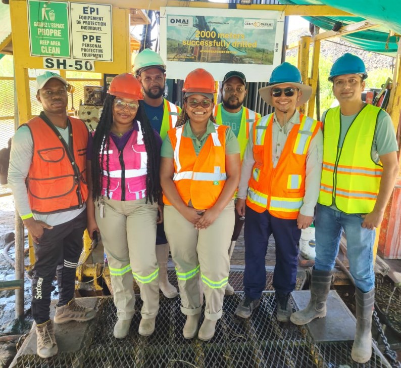
Photo 1. Team Omai celebrated the success reaching the targeted 2,000m mark on deep hole 122. We extend thanks to our great drillers from Orbit Garant.
To view an enhanced version of this graphic, please visit:
https://images.newsfilecorp.com/files/8712/272925_f9c00b1744c5fa66_004full.jpg
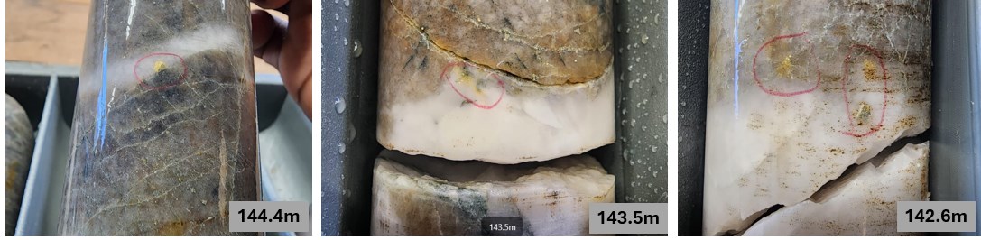
Photo 2. Visible Gold in Hole 25ODD-135 (Camp Zone)
To view an enhanced version of this graphic, please visit:
https://images.newsfilecorp.com/files/8712/272925_f9c00b1744c5fa66_005full.jpg
![]()
To view the source version of this press release, please visit https://www.newsfilecorp.com/release/272925